 Almost exactly sixty five years ago, on March 30th, 1938, the noted Maya archaeologist J. Eric S. Thompson arrived at a jungle-shrouded ruin in the far northwest of British Honduras, a Crown Colony on the east coast of the Yucatan Peninsula, bordering on Mexico and Guatemala. The site had been reported by a chiclero – a chewing-gum collector who tapped the sapodilla trees scattered through the rainforest – and reputedly had at least fourteen carved stelae. These monuments, which we now know were dedicated by Classic Maya kings on important occasions, bear inscriptions in Maya hieroglyphic script recording dynastic history, usually with a date in the Maya Long Count which enables the monument to be correlated with a precise date in our own calendar; most stelae were dedicated between A.D. 300 and 900.
Thompson named the ruin ‘La Milpa’, ‘the cornfield’, because the nearest chiclero camp a few miles away had a small milpa to supply the men with fresh maize during their months of seeking mature sapodilla trees to bleed for their latex. His field notes include a rapid sketch-plan of what we now call the Great Plaza, or Plaza A, marking the locations of twelve stelae. Thompson recorded glyphs on several of them, but most were eroded: only one monument, Stela 7, had a readable hieroglyphic date, 9.17.10.0.0 12 Ahau 8 Pax in the Maya Long Count, the equivalent of November 28th, A.D. 780. Several others were similar in style, and it seemed clear that the rulers of La Milpa had flourished during at least the late eighth and early ninth centuries.
He thought that La Milpa was not important enough, either in size or in monuments, to be worth the considerable cost of mounting a proper exploration deep into the forest, and after only two days, during which he had to contend with intestinal problems brought on by the bad water in the local aguada, Thompson left. It was his last exploration of an unknown Maya site: for the remaining almost four decades of his life he worked on deciphering Maya glyphs, and integrating ethnohistoric and ethnographic knowledge of the historic Maya with what could be elucidated about their prehispanic forebears.
La Milpa remained uninvestigated until the late 1980s, when a new road was pushed through the forest, from the Mennonite settlement of Blue Creek south to the old chiclero camp at Gallon Jug, which was being reopened and cleared for agriculture. By this time British Honduras had become Belize, and Belize’s Archaeological Commissioner was told of looting in the region, and reports of large-scale marijuana growing. Both turned out to be true. Shortly afterwards, a large area of land was bought by Programme for Belize (PfB), an environmental non-profit group founded by the Massachusetts Audubon Society and by Belizeans concerned about the shrinking rainforest habitat in Central America and the decline in animal and bird species. PfB found that their third of a million acres of forest included this large Maya city (it later turned out that there were dozens of other sites, some not that much smaller: these are being studied by our colleagues from the University of Texas, under Professor Fred Valdez, Jr.): they commissioned a report, and Boston University was brought in.
We proposed to start with a mapping programme using an EDMI (electronic distance measuring instrument); first we would investigate the central square kilometre and then we would do two long narrow transects to the east and the south to find out the extent of the city. A series of randomly-positioned Survey Blocks would give us a statistically-robust sample of terrain and settlement pattern against which to match the other evidence. We would also carry out excavations in both core and periphery to build up a community history, and to see how far some of the central buildings could be restored for tourism.
All of this had to be done under one major constraint: La Milpa lay in a biological reserve, and we could not clear-cut forest to uncover buildings or even to create the long lines of sight that our transects needed. Undergrowth such as vines and the myriad other plants – most with sharp spines or other unpleasant protective features – that grew at ground level could be cleared, but for any tree more than six inches in diameter at chest height we had to obtain per-tree permission from PfB’s rangers. This also meant that we could not strip soil and debris from the mounds to ascertain their original form and assess how far they could be restored. However, we had an alternative avenue of approach.
Looters had attacked La Milpa thoroughly in 1979-81, digging large trenches into virtually every large structure in the site core and many in the surrounding settlement in search of tombs: over the past quarter century Maya polychrome vases and carved jades have become fashionable among collectors of Pre-Columbian art and museums (such as Boston’s Museum of Fine Arts, which has a substantial collection of such ‘unprovenanced’ objects, including at least one polychrome vessel likely to be from La Milpa), and the high prices fetched – sometimes in the millions of dollars – have underwritten further looting.
We took as one of our basic tactics the cleaning and recording of such looters’ trenches, which gave us cross-sections through the architecture of numerous buildings and enabled us to date them.
The Ceremonial Centre
What did a Maya city really look like? At the heart of every great Maya city is the ‘ceremonial centre’ with a central plaza surrounded by the huge steep pyramids. At La Milpa the Great Plaza is set on a hill-top and was huge – large enough to hold two football matches, and surrounded by four huge pyramids, emerging from the jungle. By following the looters’ trenches, we were able to carry out two major excavations at two corners of the largest of them, Pyramid 1. At the southern corner a complete temple was excavated which had been covered by the deposits eroded from the pyramid after it had been abandoned. It is fronted by Stela 7 which is the only dated stela, dating to November 28th, AD 780. The stela is set into a plaster floor which runs under Temple 5 so that it provides the date before which the temple was constructed.
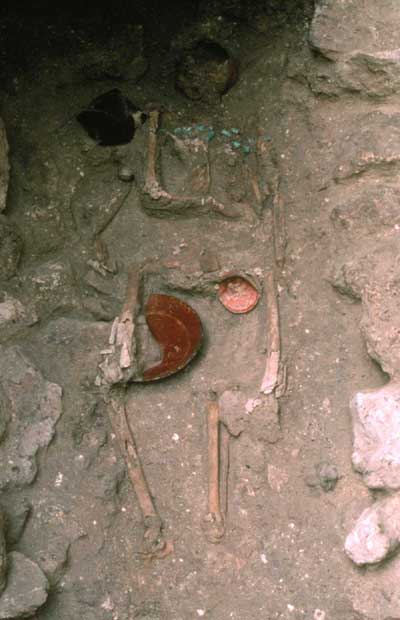
The excitement came however, near the northwest corner of the pyramid where an untouched royal tomb was discovered. We stumbled upon this by accident when we were looking for the (non-existent) setting for the recumbent Stela 1, late in the 1993 season. We hit a deposit with alternating layers of limestone slabs and chert flakes: such deposits were commonly used in the ceremonial closing of the shafts of noble or royal tombs. With no time to investigate, we refilled the excavation and reopened it in 1996.
The deposit, including nearly 17,000 chert flakes, did indeed fill a shaft cut down into bedrock, where a rough stone corbel vault within the small chamber protected a single burial. Julie and Frank Saul identified him as a man of 35-50, who had lost all his teeth long before death, and who had a permanent neck injury that could have been caused in battle, or by playing the ball game. His grave goods were odd and few, given the elaboration of his tomb. There was only one ‘royal’ object: across the chest of the corpse had been laid a splendid collar of carved and colourmatched jade beads, with a pendant in the form of a vulture head. The Maya used such a head in their hieroglyphic script as a synonym for ahaw, ‘lord, ruler’: this surely indicates that he was in fact, a king.
However he was not given a normal royal burial. The closed-up shaft had not been marked with any mound or monument – which is why it had escaped the looters. The grave assemblage is poor, suggesting a hurried burial, although observing the rites appropriate to a man of pedigree. The date too is a problem: an AMS (small sample radiocarbon) date on collagen from the skeleton suggests death as early as A.D. 220-350, but the style of the pottery vessels is at least a century later. The unmarked grave would accord better with an even later date, in the later fifth century. This was a time when La Milpa was in temporary decline: could it be that that the burial was indeed of a king, but one who had come to a sticky end, and was thus given this hurried and unmarked burial?
The palace
The royal palace was part of the ceremonial centre, but lay some distance to the south of the Great Plaza, connected to it by a raised causeway, known as a sacbe. The palace was a complex of courtyards raised above a smaller plaza which we named Plaza C. A robbers’ trench had gone through the centre of the throne room, and we were able to recognise part of the throne, with its elaborate polychrome frontage.
More exciting, perhaps, were two smaller palaces, one to the east, one to the west, which may have been the places where the ruler actually lived. Both appeared to have the essential characteristics of a palace, an audience courtyard and a throne room, with an adjacent domestic area. In the western palace the throne was a substantial structure, three metres wide and two metres deep, large enough to accommodate the whole royal family, as indeed some the well known Bonampak murals suggest. It was, however, a deceptively economical construction: instead of being made from slabs of stone, it was built of rubble, plastered over and then painted. In the Western Palace the front was painted in a deep red, but in the East Palace as well as the main palace the front had a polychrome decoration with imitation legs painted in low relief.
Cosmology
One of the most remarkable discoveries at La Milpa was that we were able to work out something of the cosmological layout of the whole site. Gair Tourtellot directed a meticulous survey of the site periphery. The expedition surveyed two long transects, each 200m wide, one stretching 6 km to the east to beyond the limits of the settlement, and a shorter transect running 4 km to the south (see map overleaf). A notable discovery was in the east transect, where another plaza was discovered, called La Milpa East. Here the hilltop had been flattened to form a plaza large enough to have held 5,000 people. It is the third largest on the whole site, bigger indeed than Plaza C at the base of the palace acropolis. On three sides there were long narrow multi-room structures, while on the fourth there was a small pyramid. There was also a stela – the only one to be found outside the ceremonial precinct. Accurate survey and viewshed analysis revealed that if the jungle had been cleared away, the pyramid and stela would have been due east of and inter-visible with Temple 1 on the Great Plaza. Was this significant?
Mapping of the south transect had by this time already extended out 3.5 kilometres from the centre, where to our surprise and delight a similar ‘minor centre’ was discovered, again on a hilltop, again intervisible with Temple 1. The axes from Temple 1 on the Great Plaza to La Milpa East and La Milpa South are precisely 90 degrees apart, and almost exactly oriented to the true (rather than the magnetic) cardinal points. Were there similar centres waiting to be discovered to the north and west and if so, did they form a cardinally aligned cosmogram?
The following season (in 2000) we returned, this time equipped with GPS systems, so that we could navigate by satellite in the rainforest. Searching due west along logging roads, at 3.5 kilometres out, atop a hill we found what we were looking for, another minor centre on a hilltop within a few metres of the predicted location. The marvellous confirming feature was the seven metres tall pyramid on the west side of the plaza: it faced directly east to La Milpa Centre, and mirrored the pattern of La Milpa East.
Would there be a similar site at La Milpa North? It took only two days of searching to find what we were looking for, again close to the predicted location. This time however, it was rather different. There was no temple, no plaza, but instead a line of hilltop courtyards, the signature of a Maya palace with residential as well as ritual functions.
Is there some grand cosmological function here, with a cruciform cosmogram? The East and the West Plaza mirror each other: the sun rises in the east, then passes over the site core at zenith before descending though La Milpa West to the hidden underworld and through it to rise again in the east next day. This vertical-circle model was flipped on it side by the Maya, who used the north as a proxy for the zenith, and south for the underworld. In La Milpa’s four cardinal, equidistant and intervisible minor centres, Maya cosmology is revealed.
Where did the people actually live?
Spectacular though the central area may have been, it was also the centre of a huge sprawling town, which spread over 78 square kilometres, and may have contained up to 50,000 inhabitants at its height. Maya cities were quite unlike Near Eastern or Mediterranean towns. It was a ‘garden city’: instead of the houses being densely packed together, they are spread out in little farmsteads scattered over the countryside, each surrounded by its gardens and orchards. Mostly they survive only as house platforms, but some are arranged round a courtyard, sometimes even a double courtyard. They are surrounded by terraces, stony berms, and piles of rocks that make up the gardens, with property walls dividing one family from another. Mostly they were low-lying, on land that was more easily cultivated. On the hillocks were more substantial structures which were presumably the dwellings of the local élite, centres for management and control.
Dating
What was the date of La Milpa? Perhaps surprisingly, it appears that the great city itself was comparatively short-lived, lasting only a couple of centuries, from around A.D. 700 to its sudden collapse round A.D. 840. However the central core was much earlier. It proved to have been first settled around 400-300 B.C., as a hilltop settlement on the high ridgetop that underlies the Great Plaza: a dense layer of trash from this Late Preclassic period was found at the base of almost all our probes, dimishing when we moved outside this area to scattered sherds. The first La Milpa seems to have been a small village, one of several in the vicinity judging by the occurrence of Late Preclassic trash identified by Kerry Sagebiel at several locations in the settlement zone.
However, in the Early Classic period (A.D. 250 to 600) the first ceremonial buildings began to appear on the eastern side of the Great Plaza, low platforms of cut soft limestone blocks covered with plaster. Temple 5, which is the small building at the corner of the great Pyramid, Temple 1, was one of these, with a line of cache vessels dedicated in front of it and buried by a new plaza floor. An equally early building probably underlay the northern end of the huge Structure 3 pyramid.
The carved stelae also appear to have fallen into two groups – early and late – and several were dedicated to the rulers of this Early Classic period, though apart from Stela 10, none remained complete and in situ. While only the later Stela 7 has a legible text, our epigrapher, Dr. Nikolai Grube (University of Bonn), considers Stelae 1 and 16 to date between A.D. 317 and 514 (8.14.0.0.0 and 9.4.0.0.0 in the Maya Long Count), and Stela 15 probably lies within this span.
But what happened between the Early Classic period (A.D. 250-600) and the middle of the Late Classic period (A.D. 700-840)? Very little pottery of the sixth and seventh centuries has been found at La Milpa, suggesting that it may have been almost completely abandoned at this time: was this linked with the long-lasting struggle between Tikal and Calakmul, which ran from the middle of the sixth to the end of the seventh century? The very strange ‘royal’ tomb, described above, may belong to this period. Tikal’s victory in A.D. 695 was followed by a rapid resurgence, something we see also at La Milpa.
The eighth and early ninth centuries were La Milpa’s time of greatest prosperity: the overwhelming majority of the pottery collections and the buildings from which they come, date to this period, when the population may have risen as high as 50,000. In the Great Plaza we see this revival in many ways: new monuments were dedicated, including Stelae 7, 8, 11 and 12, all still in position along the east side of the plaza. Stela 12 is the southernmost, and earliest in style, although no date is preserved. The only readable glyph is, by good luck, the Emblem Glyph which denotes the La Milpa polity. Stela 7 remains the only fully legible text: the ruler Ukay dedicated it in November of A.D. 780 at the time of the new moon.
But some time between A.D. 830 and 850, La Milpa ‘collapsed’. The northwestern and northern sides of the Great Plaza had no buildings, merely long, low mounds which look unfinished, as though more was intended to happen. The fifth large pyramid, Structure 21 on the large southern Plaza B, lacks masonry facing, a stair, and a superstructure. A major extension of the main palace was left unfinished. Between the Great Plaza and Plaza B was a quarry with freshly-made blocks stockpiled ready for use. Similar evidence of sudden abandonment was found in the outlying minor centres. La Milpa went out with a bang, but a silent one: we have no evidence for invasion, destruction or any other explanation for why, in the middle of a major royal building program that embraced the palace, a temple, several other major structures in the core, and an ambitious overarching cosmic landscape design, it all fell apart.
This article is an extract from the full article published in World Archaeology Issue 1. Click here to subscribe


