 Both new technologies and traditional techniques are behind major advances along the German frontier. Matt Symonds reports in.
It is the sheer scale of Rome’s German frontier that overwhelms you. Running for almost 550km, and boasting at least 60 forts, 80 fortlets and over 900 towers, it is the longest archaeological monument in Central Europe. From Rheinbrohl (near Koblenz) on the Rhine, to Eining (near Regensburg) on the Danube, the frontier’s circuitous and occasionally bewildering path carries it from mountain ridges to river pastures, sometimes heeding the limits of fertile farmland, others simply ploughing an arbitrary line across the landscape. This complex barrier is more than just an extended display of Imperial might, it is a physical testament to the way terrain forced the military’s hand.
Across most of Europe the army turned to the great rivers, the Rhine and the Danube, when securing the borders of Rome’s dominion. Clever use of men and terrain transformed these natural highways into fortified obstacles that marked the edge of empire and, in Roman eyes, the end of the civilised world. But by a quirk of geography, the very rivers that formed the backbone of the European frontier also threatened the heart of the Imperial state. Both rivers rise from mountainous terrain in southern Germany and Switzerland, and at their closest pass within just 25km of each other. As well as slowing communications between the Roman provinces of Germania and Raetia, the course of the rivers near their sources formed a natural funnel, channelling the restless peoples beyond the frontier towards the Alpine passes, and Italy.
Despite its strategic importance, the land frontier developed gradually as the ruthlessly expansionist Roman state slowly grasped that its armies had stalled. The Batavian revolt in AD 69 first brought home the need to create a permanent presence beyond the upper reaches of the Rhine and Danube. Set against an episode of civil war that has gone down in history as ‘the year of the four Emperors’, the Batavian uprising plunged the lower Rhine into chaos. Some Roman units even sided with the rebels, a betrayal the ancient historian Tacitus lambasts as ‘a deed of shame without parallel’. Stamping out this insurrection was severely hampered by the lack of a direct link between the Rhine and Danube forces. Vespasian, the last of the four emperors standing, remedied this by commissioning a road that crossed the rivers, creating a short cut between the two regions.
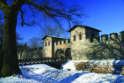
Thereafter, permanent military bases in the area multiplied until, in Germany as in Britain, the existing security arrangements were consolidated into a formal frontier line by the Emperor Hadrian (AD 117-138). But the land frontier he crafted in Germany is no second fiddle to the famous Wall that carries his name in Britain (see CA 240). The subject of intensive investigation since the late 1800s, the German frontier became a UNESCO World Heritage Site in 2005.
The following gives just a taste of the breakthroughs its flourishing research community have achieved over the past decade.
A tale of two frontiers
Roman frontiers were not blindly regurgitated from a standard Imperial blueprint. Although both the German limes and Britain’s Hadrian’s Wall were products of the Hadrianic masterplan to secure the Roman Empire within permanent borders, the results are not uniform. While the focus is often on their similarities, the differences are equally enlightening. At only a quarter the length, Hadrian’s Wallshould be very much the junior partner, but it was fashioned into a far more substantial obstacle. Its stone curtain wall, up to 3m wide, is in a different league to the timber German palisade. This is not purely cosmetic: patrolling along the top of the palisade would have been impossible, while the scale of the stone wall implies thatHadrian’s Wallhad just such an elevated sentry way.
The forces tasked with ensuring frontier security were also deployed differently. The fortlets and turrets on Hadrian’s Wall were shoehorned into a regular sequence and positioned with wearying predictability at third-of-a-mile intervals. On the German limes similar installations were placed far more carefully within the landscape, and built, enlarged, or abandoned as circumstances dictated. This flexible and responsive system contrasts with Hadrian’s Wall which, with the exception of a late-2nd-century cull of turrets, quickly fossilised once completed in stone.
A screen of outpost forts was maintained beyond Hadrian’s Wall for most of its existence, but a similar precaution was not adopted in Germany. Such variations in technique can be interpreted in many ways, with the length of frontier and availability of resources undoubtedly factors, but it is tempting to see the influence of different types of threat too.
Limits of Empire
For much of its course the land frontier, or limes as it is known, was originally marked by a stout timber palisade, with the fortlets and towers set back from it, creating a broad frontier strip. Whether this strip provided a simple line of demarcation, a customs barrier, or even a military stop-line remains disputed.
Archive photographs from the late 1800s show pioneers of frontier studies posing next to the stumps of palisade posts, still preserved in stagnant bogs. Their excavations revealed timbers half a metre in diameter, highlighting the environmental cost of this new frontier: about 700 century-old trees had to be felled for every kilometre of palisade.
The striking similarities between this barrier and a comment in a 4th-century biography of Hadrian describing ‘great stakes driven deep into the ground and fastened together in the manner of a palisade’, swiftly saw the frontier fence declared his work. This traditional reading of the ancient sources was recently confirmed when tree-ring analysis revealed that the oak palisade posts at Markˆbel were cut down in the winter of AD 119/120. This date still surprised though, as it was widely assumed that Hadrian ordered the frontier to be built during his tour of Germany in AD 121. Instead, the army pre-empted his arrival, perhaps allowing him to inspect the work in progress.
The length of the German frontier brought it within the Roman provinces of both Germania Superior and Raetia, placing it under the jurisdiction of two different governors. The impact of this split is apparent in the eventual replacement of the palisade with a barrier less susceptible to rotting. In Germania Superior a 6m-7m wide ditch was cut, with the spoil heaped up behind it to form an earth mound, creating an obstacle called the Pfahlgraben. However, in Raetia the new barrier took a very different form. A rough stone wall about 1.2m wide, dubbed the Teufelmauer, or Devil’s wall, was erected. There was no ditch. Traditionally, if tentatively, associated with the Emperor Caracalla’s German campaign around AD 213, attempts to understand the military context of these upgrades have always been hamstrung by a chronic shortage of dating evidence. This is particularly true of the Teufelmauer, the origin, construction, and height of which has been one of the most enduring mysteries of the German limes.
Thielenhofen exposed
The 2nd-century fort at Thielenhofen lies in a field about 2km behind the frontier line. Originally the base for a cavalry cohort, there is nothing to be seen at the site today. However, geophysical survey has revealed the fort internal buildings (right), with its central headquarters building showing up particularly clearly. The lines of black dots both north and south of it are urine pits for horses stabled in the cavalry barracks. To the left of the fort a second, previously unknown, fortification is visible. This may have served as a construction camp while the stone fort was being built. It is overlain by the extramural settlement that grew up outside the fort, offering a range of services designed to part the soldiery from their pay.
Further survey has recently revealed a possible forum and theatre north-east of the fort, indicating the size of this settlement.
Virtual survey
One of the obstacles to investigating the Roman border has always been the dense tree cover. While these huge tracts of forest helped preserve the fragile frontier earthworks, the undergrowth can obscure as well as protect. However, a new form of aerial survey commissioned in the wake of the frontier’s elevation to World Heritage status has solved this problem in style. LiDAR, or light detection and ranging, uses an aircraft mounted instrument to fire thousands of laser pulses a second at the ground. Some of the energy from these pulses will be directly reflected from the forest canopy, and some from the ground below. This latter can virtually strip away the conifer cover, and has revealed the course of the frontier in startling detail.
This cutting-edge reconnaissance has provided a glut of information. Amongst the new sites to be discovered is a timber tower on the Raetian stretch of frontier. Although lying only 20m from the remains of a stone successor that have been known for over a century, the forest had successfully concealed the modest tower earthworks from generations of visitors. Equally overlooked were the pits pockmarking the area both north and south of the line of the Teufelmauer. Petering out away from the frontier, and uninfluenced by areas of Medieval or modern development, it seems that these pits were miniature quarries, opened up by building gangs working on the Teufelmauer to extract the material necessary for the new stone barrier.
The LiDAR data has even contributed to the debate surrounding the original height of this wall. The previous best guess of around 2.5m was based on the excavation of tumbled material. However, survey of the seemingly undisturbed stretch of collapsed Teufelmauer in Hienheimer forest revealed a rubble spread of 3.4m³, compatible with an original height of around 3m. Tantalisingly, this is equivalent to 10 Roman feet, exactly the sort of round number favoured by frontier architects.
Dating the Devil’s Wall
What this survey cannot do, is help to date either the stone wall, or upper German earthwork. The strongest evidence for the Pfahlgraben is a solitary denarius coin of AD 194 found under the earth bank near the Saalburg fort. Until recently there was no direct evidence to date the Teufelmauer at all. Yet a potential solution came to light way back in 1892 when local chemist W Kohl, digging to the north of the 2nd-century fort at Dambach, discovered timber stumps in the waterlogged ground at Kreutweiher. But these were not relics of the Hadrianic palisade. Instead the posts were set close together in disorderly ranks five or six wide. Kohl had discovered the rammed-timber foundation raft that carried the Teufelmauer across this morass. Following the spectacular success of tree-ring dating on the palisade at Markobel, the potential for the estimated 2,000 posts to solve one of the great frontier mysteries was clear. But there was a catch. The area where Kohl found the posts is underwater.
Artificially flooded in the 1700s and used to power a forge mill, the Kreutweiher creek is now a popular venue for local fishermen. Yet every decade the waters are briefly drained. The most recent occasion was in 2008, and archaeologists seized the three-day window to scour the bog for timber foundations. Faced with this Time Team style deadline, they focused on the area already disturbed by Kohl, and eventually located the posts under a metre of quagmire. With timbers measuring over 3m, recovery was not straightforward, but eight foundation timbers were eventually lifted from the lake bed. Although five were alder, and could not be dated, cleaning revealed numbers notched into their sides, presumably by the military construction teams. The remaining three posts were oak, and careful analysis proved that they had been felled in the winter of AD 206/207. This places the upgrade a good five years before the traditional date associated with Caracalla’s German war. Instead the initiative was taken during the reign of Septimius Severus, and in particular just before he embarked on the ill-fated British campaign that would end with his death in York in AD 211.
It was an appropriate moment to bolster the frontier defences. Whether or not a narrow stone wall or a simple bank and ditch provided much more protection than a timber palisade is disputable. That the frontier was an increasingly dangerous place is not. Caracalla’s campaigns in AD 213 introduced the army to a new and resourceful foe, the Alamanni. In AD 233 they were back in force, breaching the frontier and running rampant until Roman forces wrested back control two years later. Although the limes installations were diligently recommissioned, this restoration proved a false dawn. After years of persistent pressure the land frontier was finally surrendered around AD 260, when the army retreated back behind the Rhine and Danube. The Alpine passes to Italy beckoned once more.
Out on a limb
The fort at Dambach lies high and dry on a shelf of raised ground in a boggy area. Excavations in the 1970s to the east of the fort revealed the well-preserved remains of a waterlogged timber building in the Moosweiher, or old pond. This building belonged to the extramural settlement or military vicus outside the fort, and a scatter of metalworking debris identified it as a workshop.
Planned improvements to the pond banks in 2006 provided an urgent incentive to return to the Moosweiher. The biggest surprise came from a spring near the eastern edge of the site. A timber frame had been constructed here between AD 182 and 192, and on its southern side was a deposit containing a cache of dismembered wooden limbs up to 73cm in length. Similar, though smaller, finds in stone or metal are well-known in Roman religious sanctuaries elsewhere. Such votives were dedicated to healing deities, often water nymphs, in the hope that they would intervene to cure the dedicant of an ailment in that limb.
This article can be found in Current World Archaeology Issue 44. Click here to subscribe