 Last autumn, Neil Faulkner, Features Editor of our sister magazine Current Archaeology, set out to find the archaeology of Lawrence of Arabia’s war.
We had launched the dig in the pages of Current World Archaeology and it was fast picked up by the national press. There were 28 participants in all, consisting of directors, supervisors and volunteers. We were delighted that so many of the volunteers were CWA readers. Thus the project has become something of a CWA dig.
The results were so rewarding that the second field season is already being planned, and CWA will continue to be a first port of call for announcing the latest discoveries. In future we hope that it will be CWA readers who will be reporting from the field on this path-breaking research. Here, though, we give the directors’ view of their first field season.
The archaeology of Lawrence of Arabia’s war? We had very little idea what this would mean. A modern scientific archaeology of the First World War is a recent development, and most of what has been done so far has occurred in North East France and Belgian Flanders (CWA10). Here, on the former Western Front, archaeology is as grim as it gets. The war was fought underground, in trenches, dugouts and tunnels. The same ground was churned again and again by shelling. The earth is saturated with munitions. There are bits of body everywhere in the mud.
But what would the First World War look like in Southern Jordan? No-one had ever tried to find out. Archaeologically it was terra incognita. To the west, in what was then Palestine and is now Israel, the British and the German-led Ottoman Turks had fought a fairly conventional war. As on the Western Front, there were lines of trenches, barbed-wire entanglements, and head-to-head battles in which machine guns slaughtered attacking infantry.
There were even tanks and fighter aircraft. But east of the Jordan valley, in the country that is today the Hashemite Kingdom of Jordan, a very different kind of war was fought.
It has been called many things: irregular warfare, guerrilla warfare, people’s war, protracted war, resistance war, the war of the flea – all implying a form of war in which one side may be stronger in men, firepower and logistics, but the other resists with improvised weapons, popular support, and endless patience, fighting a makeshift war of hit-and-run and slow, deliberate, debilitating attrition. What would be the archaeological imprint of such a conflict? We were about to find out.
We worked on two sites. One of these lies on the south-eastern edge of Ma’an, the largest town in Southern Jordan, where an important Hijaz Railway station is located. The Hijaz was the famous line that ran from Damascus in Syria to the holy city of Medina in Western Arabia. For the Ottomans, it was a symbol of their religious piety, since it carried pilgrims on the Hajj, and also a strategic lifeline securing a grip on their fractious Arab territories. Ma’an was the most important point on the line between Amman and Medina. Traditionally it was a watering place where the north-south pilgrim route intersected with important eastwest caravan routes, including one to Petra in the mountains to the west, and another to Aqaba on the Red Sea far to the south. A town had grown up here from medieval times (and probably earlier) as a settlement of Bedouin and traders, one which had around 700 flat-roofed mud houses when the railway arrived in 1904.
‘Is this what I think it is?’ We were at the Amman offices of the Council for British Research in the Levant, and Duncan Ward, a young archaeologist working as a researcher for us, had been looking through a set of air photos.
He was holding up an aerial image taken by Bob Bewley and David Kennedy in 2000. It looked like one of those air-reconnaissance photos taken over the Western Front in the First World War: a long line of key-shaped zigzags was stretched across the image from top to bottom. ‘It can’t be!’ But it was. In fact we now know that there are miles and miles of strategically located and meticulously built Ottoman trenches snaking across the hills, mountains and wadis of Southern Jordan. You can see it on Google Earth. Our landscape archaeologist, John Winterburn, is already overwhelmed by how much there is to record. The astonishing aerial photo Bewley and Kennedy had taken was of the trenches around Ma’an Station.
From other photos, from scanning Google Earth, from field reconnaissance, we now realise that the Ottoman Army turned Ma’an into a huge fortress, with almost every hilltop and ridge entrenched, stretching for miles across this desert-margin landscape. And there it remains, virtually untouched for almost a century, waiting to be mapped and explored, an entire militarised landscape that bears silent witness to the revolt that engulfed the Arab lands of the Ottoman Empire between 1916 and 1918. A First World War trench fortress Today, a small Arab workers’ village nestles against the Late Ottoman buildings at Ma’an Station, for at this point the railway still functions, mainly to transport phosphates, one of Jordan’s principal exports. On the high ground to the west, on a ridge known as the Hill of the Birds, lies the Ottoman trench system photographed by Bewley and Kennedy in 2000.
The defences here comprise: a north-west-facing firing trench approximately 725m long; a southwest- facing firing trench approximately 500m long; communication trenches serving these; and three hilltop redoubts, which, for convenience, we dubbed the Northern, Central and Southern Redoubts. For several days we based ourselves here, parked up at the Northern Redoubt, to carry out preliminary surveys and trench excavation.
John Winterburn mapped the trenches. As well as being dynamic, he is a highly innovative and technically savvy fieldworker. Time was limited, so he used a GPS (global positioning system) receiver set to record its location every second, and then moved along the trenches at a slow walking pace, taking an automatic reading every metre or so, logging around 3,600 points in the landscape per hour. The data were later converted into plots using GIS (geographical information system) computer software.
Meanwhile, the geophysicists were running test magnetometer survey grids. They had decided against electrical resistance because of the dry ground conditions, but they were not sure how well ‘magnetics’would work either.
The closer you go to the equator, the flatter the earth’s magnetic field becomes: how well would anomalies register in Jordan compared with Britain? Working close to an Arab village, there was a spread of modern metal debris too dense to clear: would these ‘ferrous spikes’ blot out any quality information? The metal-detectorists were also busy surveying – doing rapid general scans to get a feel for the ‘metal signature’ of the site. What soon became clear was that we were on an actual combat site – a place where a battle had been fought. There was little of the debris of everyday life. These trenches had not been lived in. The troops had presumably occupied a tented encampment behind the ridge, manning the trenches only as sentries and lookouts unless there was actually an attack. And what the detec- torists were finding were numerous bullets, cartridges and shell shrapnel – the expended munitions of battle.
Only one battle is recorded at the site. On 17- 18 April 1918, Hashemite regulars and Bedouin irregulars of Prince Feisal’s Northern Arab Army broke through the Turkish defences and captured part of Ma’an Station. They were quickly driven out by a determined Turkish counter-attack, and then, after a four-day firefight, the Arabs retreated having lost a quarter of their men. It seems highly likely that this was the battle being revealed by the metaldetected finds. The detectorists carried out a systematic grid survey along the front line, plotting the distribution of both outgoing fire (represented by Turkish/German Mauser cartridge cases) and incoming fire (represented by British 0.303 bullets, lead shrapnel bullets, and fragments of exploded shell casing). There were variations along the line – intensive smallarms fire in one section, bursting shrapnel in another, not much at all somewhere else. We were beginning to see the shape of a battle 90 years ago, one only sketchily recorded in written sources.
The rest of the group had been divided into four digging teams. Those who worked on the front-line firing trench were rather disappointed.
The trench was shallow, very roughly hacked out, and had virtually nothing in it. At just over half a metre deep, it was a meagre defence-work. Upcast in front of the trench had been used to form a parapet, now severely eroded, which may once have been high enough to offer substantial protection. But piles of sandbags can be blasted away. To dig deep was the safest way, and this the Turks had not at first bothered to do. But, as it turned out, there was a second phase to the defences.
The communication trench leading down to the shallow front-line firing trench had been blocked when a new ring-trench was dug around the hilltop to form the Northern Redoubt. This was much deeper: a metre and a half in one excavated section, deep enough to require a rock-cut fire-step to allow men to see over a high parapet built up from layers of mud-brick, sandbagging, and cob-covered stones. In the second phase, it seems, linear defence had been abandoned in favour of deeply-entrenched hilltop redoubts with clear and intersecting fields of fire across the surrounding slopes.
For a digger, excavation is pot-luck. Because it is a journey into the unknown, you do not know whose trench will be the one that yields the most exciting finds. The team investigating the feature at the very top of the Northern Redoubt had both the heaviest labour and the richest reward at Ma’an. Huge amounts of infill had to be shovelled out as the diggers worked down into a square chamber amid swirls of dust.
They had found a command bunker, deeply excavated into bedrock, revetted with drystone masonry, and protected by a rampart of sand.
Access had been along a deep, narrow communication trench, and both bunker and trench must originally have been roofed over. An internal mud-brick wall defined a small recess just inside the entrance, perhaps for a sentry or runner. Steps had been cut into the floor leading to dugouts extending laterally into the rock.
There was not time to finish the excavation: it is work for next season. But finds from the bunker offer clues to its use. There were 43 fragments of identical brown cardboard envelopes, each with steel studs though the two top corners, several bearing traces of a triangular white decorated label: presumably some form of document wallet. Also found were two possible Turkish Army uniform fragments, and six fragments of coarse brown webbing, probably from sandbags.
Around 4,000 Ottoman troops had been stationed at Ma’an. We had shown that they had taken the trouble to fortify the high ground for miles around the station and town, creating the successive lines of a system of defence in depth.
We had also shown that, while early defences were shallow and linear, later defences consisted of hilltop strongpoints with deep-cut trenches.
The Arab Revolt may have been a guerrilla war, but the threat was serious enough to transform this part of Southern Jordan into a huge armed camp. What about elsewhere? A fortified desert railway station About 60km south along the highway from Ma’an, almost halfway to the Saudi border, lies the abandoned railway station of Wadi Rutm.
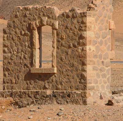
The wadi, about a kilometre across with high escarpments of orange rock bracketing a river of sand, is an empty, silent, sun-scorched wilderness. No-one lives here. There is only the detritus of occasional and short-lived Bedouin encampments. Even the railway has gone, the tracks and sleepers ripped up long ago, leaving just the sand-and-gravel embankment to mark the line, alongside three ruined station buildings. Nothing moves, except that occasionally the wind whips sand through gaping windows and doors. Sometimes archaeologists choose a site because they are awestruck when they see it. At Wadi Rutm, we first found the site, then came up with some respectable ‘research aims’.
We knew from wartime memoirs and contemporary air-reconnaissance photos that the Turks had trenches around some of the stations. But nothing was visible on the ground, and two geophysical survey transects extending outwards from the station buildings, each 100m long, failed to reveal anything suggestive.
The buildings, on the other hand, had clearly been fortified. On some parts of the line, especially towards the south where Bedouin raiding had been a problem even before the war, station buildings had been given built-in loopholes and rooftop parapets. But here, at Wadi Rutm, defensive features had been improvised, with loopholes hacked crudely through the walls, rubble parapets piled up on the roofs, and openings blocked up. Building 1, the best preserved and the one we cleared and recorded most extensively, even had a crude mud-brick extension with heating and drainage facilities, which we cannot date with confidence but suspect to belong to the First World War. But was that all: a handful of men in each of three makeshift blockhouses? We had reason to fear that Wadi Rutm might prove a dead-end: three standing buildings to record and nothing more. Had we brought 28 people to this remote spot in the desert – at huge cost in time, logistics and expense – only to find that it had never contained more than a handful of soldiers? But while the bulk of the team was focused on detail, the surveyors and detectorists were again out exploring the landscape. What they found confounded all expectations.
About 150m from the station we began to find coins. Some were simply lying on the surface, and none was deep, since they had been unable to penetrate a hard layer of compacted sand that lay just beneath the surface wind-blow. A total of 128 silver and bronze coins were recovered. On-the-spot identification by Dr Muhammad Abu Abileh established that three were Nabataean, two were Mamluk, and one Ottoman – though virtually the whole of the last 2,000 years appeared to be represented. Other medieval finds included three bronze finger-rings, three harness decorations, three bronze goat or camel bells, a possible bronze strap-end or small buckle-plate, a possible bronze purse-bar terminal, and a cylindrical weight with a crescent-moon stamp.
There was also a road. You could see it in places where the sand had blown away, and in other places it was hidden beneath low dunes. It was formed of great blocks of rough-hewn volcanic rock. Before the modern road, before the railway, stretching back at least 2,000 years, this had been a place of passage, of gathering, of trading. The rock and sand of Wadi Rutm hosted not one, but a whole series of past landscapes.
The war we were interested in suddenly looked like a speck in the passing of time.
We now knew why the station was here.
Pilgrims, traders and camel-dealers had always used this place. The railway represented merely one stage in the long development of a routeway. But this made the apparent paucity of evidence for defences yet more surprising, especially compared with the militarised landscape we had discovered at Ma’an. And then we discovered something totally unexpected.
One must walk a landscape to know it, so two of us trudged to a nearby vantage-point and spotted a distant hill overlooking a deep, sand-filled railway cutting. There was nothing special about the hill – except its location. We felt it deserved a closer look. Following the line of the abandoned track for a kilometre, and then scrambling up the slope, it immediately became clear that this flat-topped hill projected out into and commanded the entire wadi. It also became clear that this was not simply a hill with a view: it was an Ottoman Army camp.
At either end of the hill, which is about 170m long and 80m across, there were dugouts with stone parapets, at one end looking down over the railway, at the other over the long since disused and virtually invisible paved road that trailed through the centre of the wadi. Scattered across the hilltop were about two dozen rings of stone, typically 4m or so across. When the metal-detectorists scanned the surface, they found no bullets, no cartridges, no shrapnel, no evidence of combat. Instead, they found buttons, 31 in all, each with the distinctive crescent moon and star insignia of the Ottoman Army. When the excavation teams were moved from the station to the hill and began scraping and brushing the thin covering of wind-blown sand in the stone rings, they discovered other things. Not just buttons, but rusted tins, shattered vessel glass, tent pegs, fragments of lamp glass, even a complete clay pipe-bowl, and, in what may have been an officer’s tent, the remains of a newspaper. There were also food remains: an apricot stone and some grapepips.
With a minimum of post-war disturbance and a mere dusting of wind-blown sand, it was as if the Turkish soldiers had only just left.
We have now seen something of the archaeological imprint of ‘the war of the flea’. Because it was a war without frontiers, a war in which the guerrillas could strike anywhere, anytime, we find that every significant place, especially along critical lines of communication, had to be strongly defended. We also find that, while the regulars of the Ottoman Army had blockhouses, trenches, and encampments, the irregulars, the elusive Bedouin raiders with whom Lawrence fought, have left hardly any trace at all. All we saw of them was a dusting of British-supplied bullets. Asymmetrical warfare seems to leave asymmetrical imprints: a highly visible regular army confronting a shadowy, flitting, almost invisible enemy.
This article is an extract from the full article published in World Archaeology Issue 23. Click here to subscribe